


")


In 2010 Jamie Marraccini, an entrepreneur with an electrical engineering background, became president and CEO at Inertial Labs. Under his leadership the company became a world leader in real-time orientation tracking: a technology useful for an increasing number of military applications. Since then the Marraccini-led Inertial Labs has generated more than USD 50 M (EUR 44.9 M) in revenues via a geographically dispersed team of partners, talent, and key stakeholders.
Inertial Labs develops and manufactures high-performance inertial sensing solutions. This includes extremely accurate, durable, precise, and reliable inertial measurement units (IMUs), attitude and heading reference systems (AHRS), and inertial navigation systems (INS). These sensors provide motion tracking/orientation information for various defence manned and unmanned land, sea, and air platforms. Inertial Labs solutions function in real time without relying on external references such as GPS signals that can be disrupted or jammed in today’s multi-dimensional battlespace.
(Interview by Curtis Hand)
Curtis Hand (CH): Why are Inertial Labs IMUs different from other solutions in the defence and military aerospace market – vis-à-vis line-of-sight (LOS), beyond-line-of-sight (BLOS), and 3D tilt sensor applications?
Jamie Marraccini (JM): A few key aspects that set Inertial Labs’ IMUs apart from other products in the market when it comes to these various applications include:
- Our high-precision IMUs use state-of-the-art sensors, such as accelerometers, gyroscopes, and magnetometers, to deliver high-precision measurements, resulting in accurate LOS and BLOS calculations and precise 3D tilt sensor readings, which are crucial for defence applications.
- Inertial Labs’ IMUs are rugged, withstanding harsh operating environments typically encountered in defence applications.
- Our IMUs easily integrate with various defence systems, such as GPS/GNSS receivers, LiDAR systems, and other sensors for seamless legacy integration. This simplifies deployment and saves time.
- We use advanced sensor fusion algorithms and filtering techniques to deliver reliable, high-quality data from our IMUs, minimising sensor errors, impact, noise, and other factors that could compromise the data accuracy and reliability.
- Our IMUs offer a range of performance levels, allowing customers to select the right solution for specific application requirements. This will not overshadow our extensive support for system integration, calibration, and other deployment aspects, ensuring a smooth client experience.
CH: What are some of the weaknesses found in competing products that Inertial Labs uniquely overcomes?
JM: Some weaknesses found in competing products include cost-effectiveness, size and weight, performance (accuracy/reliability), flexibility of integration, customer support, and customisation.
CH: How important are two- and three-axis gyros for defence platforms and systems?
JM: Two- and three-axis gyros are critical components of many defence platforms and systems. They provide stabilisation, guidance, and navigation support to various military applications, including aircraft, missiles, ships, land vehicles, unmanned platforms, and targeting and surveillance systems.
Gyro-stabilised platforms, such as electro-optiv/infra-red sensors, radars, and laser rangefinders, are used in various targeting and surveillance systems. These platforms stabilise the sensors to allow accurate tracking and targeting, despite harsh environments or when the platform is moving.
CH: What are the advantages of weapon orientation modules and how does optical tracking figure into this solution?
JM: Weapon orientation modules (WOMs) are advanced systems with accurate information about the position, orientation, and movement of a weapon platform, enhancing the effectiveness and efficiency of the weapon system. Some advantages of WOMs include improved accuracy; enhanced situational awareness; increased stability; faster response times; and greater compatibility.
Optical tracking is a technology that can be used in conjunction with WOMs. It involves using cameras and computer vision algorithms to track and identify targets and determine their position and movement. Optical tracking can enhance the capabilities of WOMs in several ways: target acquisition and tracking; data fusion; reduced reliance on GPS; and augmented reality. WOMs play a crucial role in improving the performance and effectiveness of weapon systems. Optical tracking further enhances these capabilities by providing additional data and insights, resulting in a more versatile and efficient solution for military operations.

CH: How are motion reference units and wave sensors used on today’s warships and naval vessels?
JM: Motion reference units (MRUs) and wave sensors are essential components of modern warships and combat boats, including for high-speed boat operations. They help improve these vessels’ performance, safety, and operational effectiveness regarding navigation and stabilisation; ride control systems; dynamic positioning; structural health monitoring; launch and recovery operations; and data fusion and situational awareness.
CH: What distinguishing benefits can your AHRsS provide for indirect fires and data navigation?
JM: AHRSs are essential tools for various applications in the aerospace and defence sectors. Inertial Labs’ AHRS products provide accurate, reliable orientation, heading and positional data. This includes enhanced accuracy; rapid-response capabilities; stability and reliability; reduced dependence on external systems; and legacy systems integration. Inertial Labs’ AHRSs are lightweight and compact while able to reduce operator workload.
CH: How does a GPS-aided INS operate in denied areas where GPS is impossible?
JM: A GPS-aided INS combines the strengths of both GPS and INS technologies to provide accurate and reliable positioning and navigation information. When GPS signals are denied, jammed, or unavailable, the INS is designed to operate independently, maintaining accurate positioning for a limited time.
INSs utilise accelerometers and gyroscopes to measure an object’s acceleration and angular velocity. The system calculates the object’s position, velocity, and orientation by integrating these measurements over time. In the absence of GPS, the INS relies on two principles. The first of these is dead reckoning: estimating an object’s current position based on its previously determined position and integrating the estimated velocity over time. The INS uses this technique to calculate the object’s position as it continuously moves.
The second principle is sensor fusion. Many INSs incorporate additional sensors, such as magnetometers, barometers, or odometers, to improve the accuracy and reliability of the calculated position. These sensors provide complementary information that the system can use to correct errors that might accumulate over time.
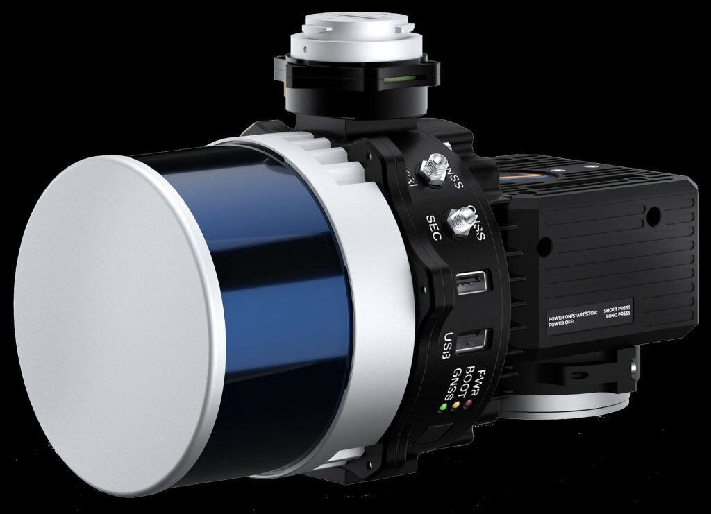
CH: Why is Inertial Labs’ Remote Sensing Payload Instrument, or RESEPI, useful for LiDAR in a military context?
JM: Our RESEPI offers high-precision measurements of position, orientation, and motion that are critical for accurate 3D mapping, target tracking, and surveillance. We provide real-time data on the platform’s attitude, velocity, and position by combining Inertial Labs’ RESEPI and IMUs with GNSS receivers and other sensors.
In a military context, LiDAR sensors mounted on unmanned aerial vehicles (UAVs) or ground-based vehicles can provide situational awareness, terrain mapping, and reconnaissance capabilities. However, precise positioning and orientation information is necessary for accurate target tracking and geolocation, especially in GPS-denied environments or when dealing with moving targets. RESEPIs can compensate for sensor drift and motion artifacts, ensuring accurate and reliable data, even in challenging operating conditions.
Moreover, RESEPIs can also provide data fusion capabilities, integrating LiDAR measurements with other sensor data, such as EO/IR imagery, to enhance target detection and identification. This is particularly useful in military operations, where real-time and accurate situational awareness is essential for tactical decision making and mission success.
CH: How can Europe’s defence industry original equipment manufacturers (OEMs) and military/navy customers adopt Inertial Labs’ technical advantages?
JM: Inertial Labs provides a range of high-performance inertial sensor systems and solutions that offer several advantages to the defence industry OEMs and their military customers across Europe. You can look at our benefits as five main points.
- First is our high degree of accuracy. Comparatively, Inertial Labs products provide highly accurate and precise position, orientation, and motion measurements. This accuracy is essential for defence applications with critical positioning and navigation.
- Second is our robustness. Withstanding extreme environmental conditions, including shock, vibration, and temperature fluctuations, our products’ robustness makes them ideal for use in harsh military environments across Europe.
- Third is ‘customisability’. By that we mean that Inertial Labs provides various customisable solutions to meet specific customer requirements. This flexibility allows defence industry OEMs and their military customers to integrate these solutions into existing systems seamlessly.
- Fourth is closely related to accuracy, which is our products’ reliability. Inertial Labs’ products require minimal maintenance, ensuring continuous operation in any environment.
- Fifth is our products’ compatibility with other systems and platforms. Our products’ compatibility makes them ideal for integrating with legacy defence platforms.
CH: Thank you, Mr Marraccini, for your insights and time.


