
")

Mine countermeasures (MCM) operators at the ‘REPMUS’ maritime uncrewed systems exercise, held in Portugal in September 2025, tested an improved data fusion construct that collated and integrated massed data from multiple sensing sources into a single, comprehensive common operating picture (COP) presented to the exercise’s naval mine warfare (NMW) battlestaff.
Data was ingested, standardised and visualised from across the 100-plus maritime uncrewed systems (MUS) supporting the MCM serials through an industry-supplied ‘ocean data warehouse’ and into a command-and-control (C2) COP available across battlestaff desks at the exercise’s MCM hub. The net effect of this streamlined process was to accelerate the injection of larger amounts of higher-quality data collected in seabed surveys into the operators’ decision-making process.
More broadly, the development is enabling MCM operators to consider new concepts and capabilities.
“We must find a way to process the massed data we now can collect in our systems,” Rear Admiral Dirk Gärtner, head of the German Navy’s Plans and Policy Directorate, told ESD in an interview at ‘REPMUS’. “The important part is to feed the data into a common system, fuse the data into the common picture, and if possible use artificial intelligence [AI] for the first analysis.”
“Now, we have the opportunity to feed in regularly all the updates and see what’s changed [on the seabed],” Rear Adm Gärtner added.
Evolving capability
Alongside rapid environmental assessment (REA), MCM was the first task for which navies introduced MUS capabilities, to remove the operator from the minefield. Today, the MCM task is tackled using different capabilities on board different uncrewed sensor and effector systems. Such is the continuing transition in capabilities and effects introduced by MUS that operators are looking to further transform how MCM is conducted.
With many different MUS vehicles provided by navies and industry, a key step in this transformation is harnessing the increasing amount of data available to the operator.
Traditional MCM techniques – even early on when using MUS – involved a mine-hunting vessel embarking the required set of systems and capabilities, deploying for a time period to a search box assigned by the Commander Task Group (CTG), and sending back written communications highlighting what had been found and cleared. Doctrine and procedures were well established. However, data flows were relatively low and slow because sonar numbers and capabilities, plus processes and technologies for data transfer, were relatively limited.
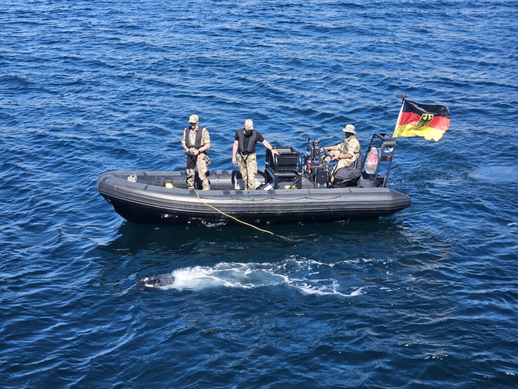
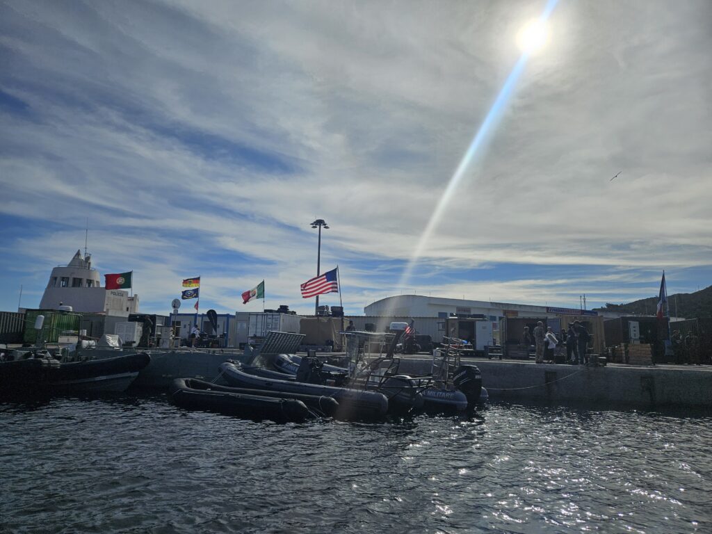
The ‘REPMUS 2025’ MCM activities – conducted at Sesimbra, west of the exercise headquarters on the Tróia peninsula – illustrated both opportunities and challenges presented by the increased MUS numbers and data generated.
More than 30 national and multinational teams brought more than 100 MUSs for testing across four weeks.
For MCM, more MUSs being present enhances surveillance spread and speed, yet individual vehicles with specific capabilities (for example, for detection and classification, identification, or disposal) need individual tasking. Moreover, the vast array of different, more capable systems generates more data, and of higher quality; this data must be collated, processed and presented to the CTG commander and NMW battlestaff.
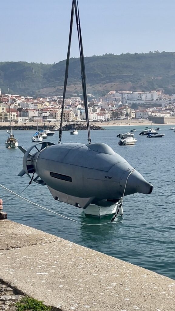
‘REPMUS 2025’ brought a huge variety of systems producing very good sonar data, Commander Andreas Montag – the German Navy’s 3rd Minesweeping Squadron Head of MUS and the ‘REPMUS’ Commander CTU NMW – told a media briefing at Sesimbra during the exercise. This variety included autonomous underwater vehicles (AUVs); remotely operated vehicles (ROVs); large vehicles launched from ship or shore; smaller vehicles launched from small vessels like RHIBs; and industry’s latest systems with the newest technologies and capabilities.
“You have a very clear and detailed picture of the sea floor, of objects on the bottom,” said Cdr Montag. “The problem is it is not such a controlled and established environment anymore …. C2 is much more complicated than before.”
The dislocation of operational structures and systems to perform the different tasks at individual levels mandates more orchestration and co-ordination by the battlestaff to integrate these inputs within the CTU; this in turn means more staff, Cdr Montag explained.
Alongside conducting efficient, effective C2 of more vehicles, managing their collective output is challenging. “We now have a huge data flow,” he added.
MCM is a time-urgent activity: threat areas need to be cleared so that high-value units can operate when and where needed. “In MCM operations you are always trying to be as fast as possible …. You must find ways to reduce the time,” Cdr Montag continued. “So, throw more autonomous systems in the water, bring them together in one network, and let them collaborate.”
This is why the exercise’s data fusion cell (DFC) is so important, he noted.
Data fusion
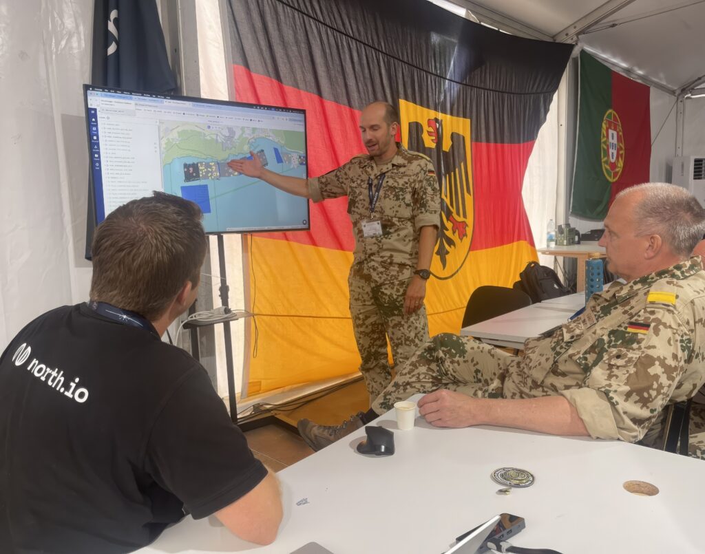
Led by NATO’s Centre for Maritime Research and Experimentation (CMRE) science and technology laboratory, supported by German ocean ‘big data’ specialist company north.io bringing its new ‘ocean data warehouse’ data fusion and management technology, and located alongside the CTU NMW battlestaff in Sesimbra, the MCM DFC was tasked with collating the various MUS data inputs and presenting the integrated outputs at the staff level as a single COP of the seabed situation.
“This was the missing piece,” said Cdr Montag. “We never had such a COP before.”
The COP showed the areas covered – or not – by MCM surveys. This overview could then be overlaid with, for example, data on critical underwater infrastructure (CUI) locations, presenting a picture of potential vulnerabilities.
“You can very easily see where are the gaps you haven’t looked at properly: something you never would have known before,” Commander Stefan Pahl, the German Navy’s NMW capability development lead, explained to ESD. “It gives you a much better assessment of what you have achieved – and especially what you have not achieved.”
Moreover, the integrated picture can be presented to operational decision makers in a matter of minutes, representing a step-change in decision-making speed, including through detection, classification and identification elements occurring simultaneously.
“The important part is the chain from the sensors – crewed or uncrewed – to the data hub where we can collect and store the data, and then present the decision makers with a quite accurate picture of what has to be done,” said Rear Adm Gärtner.
“One big advantage of the new technology we saw here was that we were able to feed the different sensor systems directly into one database,” Rear Adm Gärtner continued. “Given how fast sensor system technology emerges, we can change these systems easily or introduce sensors with different advantages, in one common database and one common picture for the decision maker.”
The rapid delivery of high-quality data (including high-resolution imagery) to the decision maker – in future, potentially in real time – also allows the data to be cross-checked by MCM experts against other data the NMW staff holds, Rear Adm Gärtner explained: previously, the decision maker had to rely on written messages based around the assessment of the operators on board the mine-hunting vessel.
Fusing the data into a single reference point enhances this cross-checking capacity, Cdr Pahl added. “You have the capability to cross-reference between different data, double- or triple-checking if the information from one system can be backed up with other information.” Cross-checking data on a mine-like object from the original sonar image against other sources like light detection and ranging (LiDAR) sensors, multi-beam echo sounders or acoustic camera sensors generates very detailed information against which very robust assessments can be made regarding whether the object is a mine or not. “With that, you save a huge amount of time in the technical and operational process,” explained Cdr Pahl.
Data process
At ‘REPMUS 2025’, the CMRE-led DFC was responsible for data management and organisation, including providing supporting architectures for the NMW activity; in so doing, it provided a centralised ‘clearing house’ function connecting the raw data, NMW staff, and data analysis functions, and supporting data flow and use from sensor to decision maker, CMRE told ESD.
Within the DFC the data fusion process was based around north.io’s ‘ocean data warehouse’, which integrates the company’s ‘Ocean Data Platform’ and ‘Ocean Data Processing Engine’ technologies. Danish company Systematic’s SitaWare software provided the C2 architecture upon which the MCM COP was hosted. At ‘REPMUS’, north.io’s ‘ocean data warehouse’ was integrated into SitaWare for the first time.
“We were the middle layer in between the data gathering entities and the COP,” Jann Wendt, north.io’s CEO, told ESD in an interview at ‘REPMUS’. Designed and developed to industry standards, the system and its data can be connected with similarly compliant NATO COPs and C2 architectures, Wendt added.
The increased MUS use was the driver behind the technology’s development, Wendt explained. “We see more autonomous systems in the water; we see more data coming. The problem – namely, time – from having a data set fully processed and having it at the CTU staff was too long.” Particularly, the vast amount of data available made reducing this timeframe difficult.
“The technology is the missing connection between the sensors and the COP,” said Wendt. “With our ‘big data’ and AI technology, we can directly draw the raw data from the sensors, process it in minutes instead of days and weeks, and push it immediately into the COP so that the CTU NMW battlestaff do not have to rely only on the operational reports [OPREPs] from those operating the systems.
“For the first time, the battlestaff could check the co-ordinates and OPREPs together with the real, highly processed, high-resolution sonar data,” he added.
The availability of increased data could also be used to verify the written OPREPs upon which MCM operations – and decisions – habitually have been based. Wendt explained that there was a risk that OPREPs could not conclude with 100% certainty that an area was clear because there might be areas for which no data was available – especially at short notice. Thus, taking a decision to send a ship into an area would have to take this into account when calculating the risk. Now, that risk can be more fully and accurately assessed.
The new approach and its technology offers a new route for tackling the NMW task’s time and risk constraints. “It changes the process, provides higher-quality data in much less time, and enables higher-quality work with less risk,” said Wendt.
At ‘REPMUS’, data was downloaded from the MUS sensors onto USB drives by the operational teams once the vehicles returned to shore. CMRE then loaded the data from the USBs into its server and data was then pushed into north.io’s ‘ocean data warehouse’ using ‘big data’ transfer protocols. The COP itself was shared via a hard-wired local area network.
“This is only the beginning,” said Cdr Montag. “The future can be that we are in the combat information centre (CIC) in a secure port, while the vehicles go out and conduct their surveys, surface, and as they return to harbour transmit data via Starlink satcom [satellite communications] or other available communications.” With data fed directly into the CIC – potentially also prioritised – post-mission analysis can begin before the vehicles return.
“From our viewpoint this is the future of NMW,” Cdr Montag added. ‘REPMUS’ provided an opportunity to demonstrate how doctrine and operations can be adapted, testing new procedures in a controlled environment with a view to pushing them out into ‘real-world’ operational doctrine, he explained.
Reflecting on how continued development of a more detailed, integrated and available COP could further re-shape NMW, Cdr Montag said such a COP, layering in data from previous surveys too (even going back several years) would be very useful. “If we’re going into an area where we were three months before, I can have a look in advance and see what the area looks like,” he continued. New imagery could indicate a change in the environment, such as more seaweed, or a change in the threat, such as more objects, he explained.
“Having all the data available in one network is crucial,” Cdr Montag concluded. “We don’t have that yet – but we are coming to it.”
“The co-ordination effort is a lot more than you would have with just the full-cycle ship, [but now] you can separate what is done where,” said Cdr Pahl. “You basically have a ‘bus driver’ for the unmanned vehicle while you send the data to a different place, so you can completely reorganise the way you work into a CIC that controls everything happening around the globe – but it doesn’t have to be on the ship.”
The new technology offers improvements for other underwater tasks, too.
The more rapid availability of more comprehensive data will improve change detection, which is as crucial in tasks like CUI security as it is in NMW. Alongside identifying if a new object on the seabed is a mine or something benign, the wide-area data integration can also detect patterns relating to a ship’s anchor being dragged across the seabed, Wendt explained. In a series of CUI incidents in the Baltic Sea between October 2023 and December 2024, several power cables and other CUI sites were damaged in events publicly attributed by NATO to rogue ‘shadow fleet’ ships deliberately dragging their anchors across the seabed. The impact of north.io’s technology here is assessing large amounts of data in a short amount of time, said Wendt.
Returning to the REA function and the original harnessing of MUS capability, at ‘REPMUS’ the new technology – especially its data processing speed – was used to support REA requirements. “REA is supporting other warfare areas with data and information, so the faster it can function, the better for the other warfare areas,” said Wendt.
Several steps are planned to further evolve north.io’s technology, Wendt continued.
The aspiration to achieve data transfer remotely, and much faster, is something the company is already testing. Working with Euroatlas, with its Greyshark AUV, as well as with EvoLogics, north.io will trial the capability to transfer data directly from the vehicle on the surface during transit. “As soon as it surfaces, we can start pushing data over; straight away, we can start tagging the data, reworking it and pushing it into the COP,” said Wendt. Implementation tests are underway, with a view to trialling the capacity at scale in 2026.
“Future NMW will be different,” said Wendt. “You will have a crewed ship, and you will have uncrewed platforms supporting the ship. You can bring the technology onto the platforms, gather the data on board and push it into shore-based centres.” “It’s the future idea of decentralisation,” Wendt concluded.