
![Cawdor Barracks in southwest Wales is currently home to the British Army’s 14 Signals Regiment. The facility will soon house the UK element of the tri-national DARC radar network for tracking objects in orbit. [Google Maps]](https://euro-sd.com/wp-content/uploads/2025/11/Cawdor-Barracks-Google-Maps-Kopie.jpg "Cawdor Barracks (Google Maps) Kopie")


David, Bishop of Mynyw, enjoyed a relatively long life for the time. Born in AD 500, he lived until AD 589, although the exact dates are disputed. His diocese was in South Wales and he would become patron saint of that country after being canonised by the Holy See in 1120. Today the city of St Davids in Pembrokeshire, southwest Wales is named after him. As well as being David’s resting place, the city is home to Cawdor Barracks, a British Army base, housing the headquarters of 14 Signal Regiment (Electronic Warfare). Cawdor Barracks is also a former airbase, known locally as ‘Bawdy’, used in the past by both the Royal Air Force (RAF) and the Fleet Air Arm. ’14 Sigs’ as the unit is known, will reportedly vacate the barracks in 2028 and relocate to Imjin Barracks, in Gloucestershire, western England. This move will not, however, mean the end of a military presence at the Welsh base as the facility is due to house the British element of the tri-nation Deep Space Advanced Radar, better known as DARC.
Australia, the United Kingdom and the United States are joining forces to realise DARC. The US Space Force (USSF) is leading the initiative with Northrop Grumman as the prime contractor for the associated radars. The remit of these radars is to track satellites, space debris and other objects in orbit, according to the USSF. A total of three radars will be constructed to watch the cosmos to this end, one in each country. All three radars are expected to be operational by the early 2030s. Space Force plans call for an eventual deployment of 27 fully networked parabolic antennas which will provide complete coverage.
Space debris continues to be a problem. The European Space Agency’s (ESA) annual Space Environment report puts the challenge into perspective, stating that up to 40,000 space-borne objects are continually tracked by space surveillance organisations worldwide. Of those objects, around 11,000 have active payloads meaning they are performing some kind of task or service. The rest can be considered as payloads that have either failed in orbit or been retired. The report adds that any object of 1 cm or above (0.4 inches) in size could cause catastrophic damage if it impacts a spacecraft in orbit. Of these potentially lethal objects, 50,000 are above 10 cm (3.9 inches) in size.
Space debris is likely to increase as the cosmos is increasingly utilised. The United Nations Office for Outer Space Affairs (UNOOSA) stated that, as of 2025, 14,904 satellites are in orbit, and the European Space Agency (ESA) has forecast that 100,000 satellites may be in orbit by 2030. The increase of space traffic will likely be driven in no small measure by the proliferation of low Earth orbit (LEO) satellites being launched by private companies to provide global communications coverage. Accepted definitions stipulate that LEO satellites orbit at altitudes of between 800 km (432 NM) and 2,000 km (1,080 NM) above the planet.
DARC formally commenced on 27 September 2023 when all three nations signed a memorandum of understanding to this effect. The three countries will also benefit from the space surveillance DARC will provide. Ground has been broken and the first site in Exmouth, Western Australia was completed in December 2024. System and integration work began soon afterwards, according to USSF documents. International collaboration in this regard makes sense, since space does not stop at borders. The heavens are a global environment which Earth depends on and tracking objects in the cosmos contributes to safe spacefaring. This is a growing concern as this environment becomes increasingly congested.
US Space Force says that one of DARC’s key missions is to track objects in geosynchronous orbit (GSO) which circumnavigate the globe every 24 hours. From the perspective of an observer on the ground, a satellite in a geosynchronous orbit returns to the same position above the Earth at the same time each sidereal day. A common subtype of GSO is the geostationary (GEO) orbit, in which a satellite appears to an observer to remain above the same spot on Earth at all times. In reality, as this spot above Earth is revolving around the planet’s axis every 24 hours, and so is the satellite. One issue with GSO/GEO orbits is that the satellites in these locations are typically at altitudes of circa 35,416 km (19,123 NM). DARC will track satellites in these orbits while also tracking other celestial objects, providing advance warning of likely collisions between the two. This is easier said than done.

Radars deployed in a single country, such as those deployed in the United States, would only ever be able to see a single swathe of space at any one time. By deploying DARC radars at geographically spaced locations in the western, eastern and southern hemispheres, and by combining their imagery, DARC users gain a comprehensive recognised space picture (RSP) of the entirety of the heavens surrounding Earth. As USSF notes, DARC radars will operate for 24 hours per day in all weathers. Taking such an approach does bring its own challenges, as the radars must be networked into command and control (C2) systems where their disparate imagery can be consolidated to create the RSP.
The vast distances involved, given the location of the radars, make adequate networking imperative. Radar imagery can be shared across satellite communications (SATCOM) links; to this end, both Australia and the United States are already users of the US Wideband Global SATCOM (WGS) constellation. Publicly available information states that the WGS constellation uses X-band (7.9 GHz to 8.4 GHz uplink/7.25 GHz to 7.75 GHz downlink) and Ka-band (26.5 GHz to 40 GHz uplink/18 GHz to 20 GHz downlink) channels. Data rates of up to 3.6 Gbps are achievable across the constellation. The UK’s Skynet-5 constellation also uses X-band and Ka-band frequencies, though the UK’s Ministry of Defence (MoD) has not released figures regarding Skynet-5’s data rates. Nonetheless, they are likely to be comparable to those of the WGS constellation, the author understands.
Imagery gathered by the radars is likely to be rich in detail. Even the smallest piece of space debris has the potential to cause catastrophic damage to a satellite – NASA has stated that some space debris can reach speeds of 54,000 km/h (29,158 kn), which is around 16.5 times faster than a typical 5.56 mm bullet. Potentially small targets detected by the DARC radars will need to be seen and shared as quickly as possible. The responsiveness of the overall DARC architecture creates another challenge as it makes communications latency a challenge that must be overcome. Latency is the measurement of how long it takes data traffic to move from one place to another. The phenomenon is often witnessed during television interviews using SATCOM links, where there can be a notable gap between a news anchor’s question and a field reporter’s answer. Latency can pose a challenge in space surveillance, as an object may have moved some significant distance in the time it may take a radar to share its imagery. Even with a delay of one second, the speeds of the space debris highlighted above would be equivalent to 15 km/s. Thus, it will be imperative that the networking knitting the DARC radars with its C2 architecture offer the lowest latency possible.
Latency is not the only challenge that physics poses to the DARC architecture. One problem with sending radio signals across vast distances into space to track what may be very small targets is that a particularly large parabolic antenna is needed to equip these radars. Parabolic antennas help to increase a radar’s gain – with gain being a measure of the amount of energy a radar can focus in a specific direction. The higher the gain, the stronger the radar signal will be. Gain can be thought of as analogous to a lens; a strong lens will magnify the light coming into it, or out of it, in a specific direction. This explains why spectacles, or even the glass from a discarded bottle, can be used to light a fire on a sunny day.
High gain has another important benefit. A basic rule of thumb in radio engineering is that the further a signal must travel, the less power it has when it reaches its destination. To see small targets in detail, a radar needs to transmit significant power to ensure that the echo produced by any target the outgoing signal collides with is powerful enough to be heard by the radar. The Earth, and the cosmos, are both full of electromagnetic noise. This cacophony can risk drowning out the echo from a potential target.
Let us take Germany’s Tracking and Imaging Radar (TIRA), operated by the Fraunhofer Institute for High Frequency Physics and Radar Techniques, located near Bonn. The radar transmits on an L-band frequency of 1.333 GHz and produces 1 MW (60 dB) of power. TIRA’s 34 m antenna has a gain of 51.3 dB and so by combining the power and antenna gain, the radar is able to produce a 111.3 dB signal. The transmission zooms out into space, collides with an object 10 cm in size and returns to Earth. That process causes the signal to lose -141.89 dB of strength, reducing it to -30.59 dB by the time it arrives back at the radar. Thus, the echo that the radar must process has just a tiny fraction of the strength of the outgoing signal.
Increasingly, radar frequency and antenna gain can be used to improve radar sensitivity. For example, let us consider all the above parameters as fixed, apart from the radar frequency and antenna size. For this scenario, we will transmit on a frequency of 8.5 GHz (X-Band) using an antenna with a 125 m diameter. The antenna will produce 78.77 dB of gain, resulting in a combined signal strength of 138.77 dB. Considering the same range and target size, the signal will lose 161.14 dB of strength during its journey. The resulting -22.37 dB echo is only a marginal improvement on the L-band transmission discussed above.
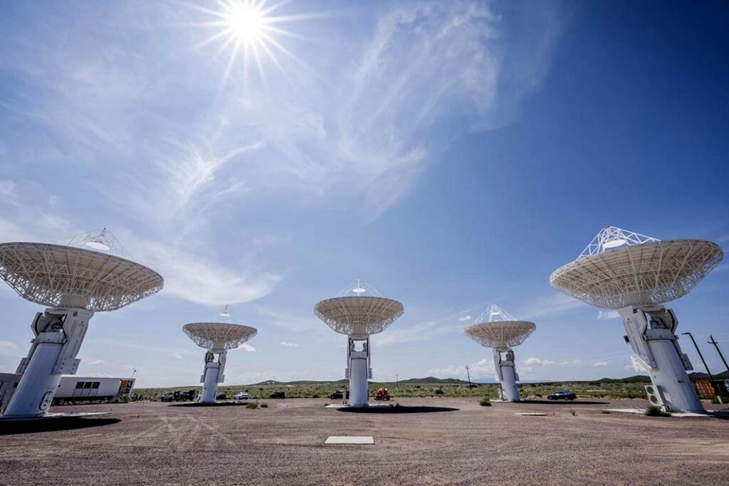
The engineers working on DARC have found a way around the antenna problem by using a multitude of smaller antennas which can be networked to artificially generate a high-gain beam. Approaching the gain problem in this way is not an abstract concept. Tests to this effect were performed at a DARC technology demonstration event at the White Sands Missile Range in New Mexico in December 2021. According to Johns Hopkins University’s Applied Physics Laboratory (APL) in Maryland, which is involved with DARC, the tests involved a subscale replica of the radar architecture. The experiments evaluated the architecture’s ability to transmit a radar signal to collide with test objects in space and to receive a workable target echo. APL says that it has made significant use of commercially available components in its work on the DARC architecture.
As noted above, the first DARC radar site in Australia was completed in December 2024, following the start of building work in October 2023. Spectrum licences have been granted by the Australian Communications and Media Authority, the country’s regulator and the first open-air radar signal was transmitted in September 2024. Space Force expect the site in Exmouth to become fully operational in 2027. The second site will be constructed in Pembrokeshire, southwest Wales, with a third to be built in the continental United States. The location for the latter site is yet to be determined. Current USSF plans call for the entire DARC architecture to be operational by 2032.
At the Pembrokeshire site in Wales, Northrop Grumman won the contract in August 2024 to provide the radar at Cawdor Barracks. Illustrating the British government’s full-throated support for the DARC initiative, a briefing on the UK MoD’s website lauds the project as being at “the cornerstone of the UK’s ability to detect, identify and track objects in Earth orbit, including satellites, space debris, and asteroids”.

The decision to site the radar at Cawdor Barracks is not without controversy. A local pressure group called the Pembrokeshire Against Radar Campaign, better known as ‘PARC Against DARC’, has convened to oppose the initiative. PARC Against DARC cites concerns over the visual impact the radar will have on the local area. Health concerns over radiation emissions from the radar are also highlighted by the pressure group, along with a perception that the construction of the radar is emblematic of what it sees as a “fading colonial era vision”. Your correspondent made numerous requests to interview PARC Against DARC but received no responses to their enquires.
Many of the DARC participants are staying taciturn on the programme. USSF chose not to provide any additional information, nor did Northrop Grumman while this article was being prepared. Nonetheless, the MoD did reveal that the British DARC radar would be the responsibility of UK Space Command alongside the UK Space Agency and the Meteorological Office. The MoD was asked how much the UK radar will cost and who will foot the bill for its construction and operation. For example, are all three nations jointly financing DARC, or is each nation individually funding its own element? The MoD stated that this information will be revealed in a Town Planning Application covering the radar’s construction.
While a successful Town Planning Application will allow building work to go ahead, details of when the UK radar will commence construction, and when it will enter service, have not been forthcoming. Again, the MoD directed your correspondent to the Town Planning Application. Reports noted that the planning permission process for DARC was underway as of February 2025. However, a report by the BBC in March 2025 said that a planning application would be submitted by the end of the year, which hints that the application has not yet been made, and that the above information may become public when it does. The BBC report continued that, pending the successful submission of the application, construction at Cawdor Barracks could commence in 2026.
There is still much to learn about DARC. No details have reached the public domain on the frequencies these radars will use. One online report spoke of the radar transmitting in X-band (8.5 GHz to 10.68 GHz), however, this does not appear to be corroborated by USSF or MoD sources. The C2 arrangements have also not been publicised. Presumably, the RSP will be shared amongst all three participant nations. Likewise, little is known about the communications arrangements as detailed above. What is known though is that the problem of space debris and damage to satellites will not diminish. DARC will have its work cut out watching the heavens above St David’s resting place, and everywhere else on Earth.
Dr Thomas Withington
![The Soviet Union constructed the Duga-1 (NATO reporting name: Steel Yard) HF OTH-B radar near the Chernobyl nuclear power station in northern Ukraine. Duga-1 was operational between 1976 and 1989 and used two antennas separated by 30 km. [Ingmar Runge, via Wikimedia Commons; CC-BY-SA 3.0]](https://euro-sd.com/wp-content/uploads/2025/11/Duga-Radar-Ingmar-Runge-Kopie-1-218x150.jpg "And the Ion will lie down with the Amp")
![Initially deployed during Operation Granby, the United Kingdom’s contribution to Operation Desert Storm in 1991, the RAF’s air-launched anti-radiation missile proved to be a radar killer. The missile remained in service, and in the RAF’s inventories, until 2013. [Thomas Withington]](https://euro-sd.com/wp-content/uploads/2025/11/ALARM-Thomas-Withington-Kopie-218x150.jpg "Stratus symbol")
![UAVs have emerged as the signature weapon of the ongoing Ukraine conflict. That country’s government plans to manufacture 4.5 million such aircraft by the end of 2025. [Trydence, via Wikimedia Commons; CC-BY-SA 4.0]](https://euro-sd.com/wp-content/uploads/2025/11/Ukrainian-Drone-Manufacture-Trydence-Kopie-218x150.jpg "Identity crisis")
![The SATURN waveform includes several important improvements vis-à-vis legacy systems, one of which is the ability to carry J-series NATO tactical datalink traffic. The carriage of J-series messages helps to improve synergies between Allied air, land and maritime forces. [US DoD]](https://euro-sd.com/wp-content/uploads/2025/09/SATURN-Radio-US-DOD-Kopie-218x150.jpg "SATURN rising")
![This image gives a good indication of how many RF antennas a modern combat aircraft must have; these are just for the plane’s electronic warfare system. [BEL]](https://euro-sd.com/wp-content/uploads/2025/09/BEL-EW-Suite-Antennas-BEL-Kopie-218x150.jpg "Doing everything at once")

![The advent of the SINCGARS radio in the 1990s was a major step forward in fostering intra-force connectivity in the US Army, and elsewhere in NATO. However, inter-force networking for land formations has, until now, remained elusive. [US Army]](https://euro-sd.com/wp-content/uploads/2025/09/SINCGARS-US-Army-Kopie-218x150.jpg "Catch the wave")
![A dummy Sherman tank, of the type used by FUSAG. [US National Archives]](https://euro-sd.com/wp-content/uploads/2025/05/Dummy-Sherman-tank_US-National-Archives-Kopie-218x150.jpg "Are you deceiving me?")