


Intelligence gathering, surveillance, and reconnaissance (ISR) are time-honoured cornerstones of military strategy. From the era of horse-mounted scouts to the epoch of globe-circling satellites, the potency of ISR lies in its power to collect, analyse, and leverage information about adversaries in the carrying out of successful military operations.
While the modes of ISR have evolved over the years, the underlying principles have remained rooted in their foundations. Before the dawn of revolutionary technologies such as drones, cameras, balloons, telescopes, and artificial intelligence (AI), ISR was vital in military affairs. Armies relied on human observation and the skills of experienced commanders to understand the terrain and evaluate enemy posture, positions, movements, and capabilities. The information gathered by observers was fundamental for operational planning, shaping the battlefield, executing the right move at the right time, and consequently, often determining the victor.
Fast-forwarding to the modern era, technology has profoundly transformed how ISR is conducted. No longer reliant on field reports by observers and reconnaissance patrols, ISR has embraced high-tech observational tools, delivering real-time, detailed, and accurate information and insight. Yet, for all the technological leaps, the age-old tenets of ISR remain as significant today as they were millennia ago. This article analyses the evolvement of ISR and offers a look ahead.
| Application | Observation Means | Mission Characteristics |
| Intelligence Gathering | LORROS, MALE/HALE UAS, Observation & SAR Satellites, SIGINT, 2D/3D Mapping | Long-range, high-volume, data collection from a stand-off range, change detection capabilities |
| Target Acquisition | MALE/Tactical/Mini UAS, Covert Ground Observation, Special Forces, JTAC | Long-range, very high accuracy, fast turnaround, concealment |
| Counter Terrorism | Mini UAS, WAMI, SAR/GMTI, Mobile Observation Systems, 3D Mapping, Change Detection | Relatively short-range, short-term persistent surveillance over designated areas, high accuracy, forensic investigation capabilities, rapid turnaround, concealment |
| Terrain Analysis | Multispectral Reconnaissance (materials, composition, ground), Change Detection, Measurement and Signature Intelligence (MASINT), Light Detection and Ranging (LIDAR), FOPEN | Broad area coverage, multispectral measurement, 3D mapping |
| Force Protection | Elevated Surveillance, Aerostat, Mini-UAS, UGVs, Ground Surveillance Radars, Unattended Sensors, WAMI, SIGINT | Wide-area persistent surveillance, life pattern analysis, anomaly detection, forensic investigation |
| Border/Coastal Protection | Physical Obstacles, Sensory Fences, Mast-mounted Sensors, Aerostats, UAVs, UGVs, Unattended Sensors, Change Detection, SIGINT, WAMI | Linear persistent surveillance, life pattern analysis, anomaly detection |
The domain of intelligence gathering has traditionally been rooted in long-range observation. For many years, holding the highest ground equated to seeing the furthest thereby giving your own forces a critical advantage. However, inventions such as the hot air balloon and aircraft revolutionised this dynamic, facilitating aerial dominance over vast, flat landscapes. However, these advances came at an elevated risk to the observers and platforms.
With the advent of reconnaissance satellites equipped with powerful telescopes or synthetic aperture radar (SAR), the risk was mitigated by providing the world’s leading governments the means to monitor any area of interest around the globe, though not in real-time.
The ushering in of unmanned systems has since democratised this realm, empowering every military, paramilitary, insurgent, and terror actor to observe and strike from the sky or sea. Visual Intelligence (VISINT) is often considered the gold standard for state and military entities. VISINT harnesses a plethora of visual information from all sources, processes it, and presents it to decision-makers for comprehensive analysis and subsequent action.
Visual Intelligence
Image acquisition methods for VISINT span a broad spectrum, ranging from spy satellites orbiting hundreds of kilometres above the Earth to high-altitude UAVs surveying vast expanses of land or sea, and even down to small, low-flying drones that capture detailed imagery of specific targets. Although the means to secure the imagery might vary, the techniques and goals remain consistent.
These systems commonly employ multi-spectral imaging, which includes visible (VIS), near-infrared (NIR), short-wave infrared (SWIR) components to sense direct and reflected light. Going beyond these, medium-wave (MWIR), and long-wave infrared (LWIR) infrared thermal sensors can detect tiny temperature variations, providing imaging of thermal signatures of objects and their surroundings. As such, these latter two can operate in total darkness, identifying objects based on their unique heat signatures rather than reflected light. These sensors are typically designed for long-range performance, extending visibility beyond national borders and facilitating stand-off operations while keeping the reconnaissance systems themselves safely out of range.
Credit: Safran
Modern VISINT systems frequently combine various sensors, some even operating simultaneously to extract a fused image that conveys more information than each channel could provide. This data is processed to highlight objects of interest. If past images of the same area exist, they are compared with new images to reveal changes indicative of enemy infrastructure build-up, force movements, logistics activities, and other preparations.
Multispectral imaging merges observations across several spectral bands, providing a deeper understanding of the scene. With this technology, analysts can see through camouflage and vegetation, identify earthwork and fortifications – even when covered – and potentially spot land mines and improvised explosive devices (IEDs) based on the subtle disruption they cause to the soil.
Previously, such processing demanded extensive communication and computing resources, available only at national-level intelligence and imagery processing centres. These centres also served other purposes, such as maintaining a ‘target repository’ for precision-guided munitions or resources for mapping and analysing potential battlefields. Today, some of these resources are more accessible, with some even available at the operational level, supporting counter-terrorism activities and special operations.
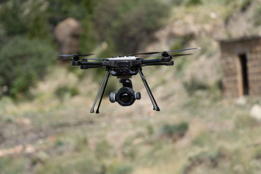
Observation systems fill intelligence and situational awareness gaps at multiple levels of a force, with ground observation posts, UAVs, and satellites are employed. However, at the tactical edge, the general trend leans toward Vertical Take-Off and Landing (VTOL) UAVs, which can deliver high-quality and responsive ISR. Sensor manufacturers are adapting to meet this need, integrating multi-sensor payloads into the low-space, weight, and power (SWaP) form factor of a few kilogrammes. Such payloads require the drone to be equipped with sufficient power to process images and videos, providing tactical users with actionable intelligence and targets. Similar capabilities have also been extended to tactical vehicles.
Credit: Teledyne FLIR
The intelligence-gathering process becomes more time-sensitive at the lower echelons for activities carried out close to one’s own forces. The time to acquire, process, and disseminate information to the user is paramount. This forms part of the ‘sensor to shooter’ cycle of target acquisition, which gained relevance with the introduction of guided munitions in the 1990s. Today, as both sides of the war in Ukraine demonstrate, target acquisition and fire direction are routinely conducted using unguided artillery, mortar, and rocket fire, with spotter drones flying over the combat zone.
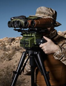
Target Acquisition
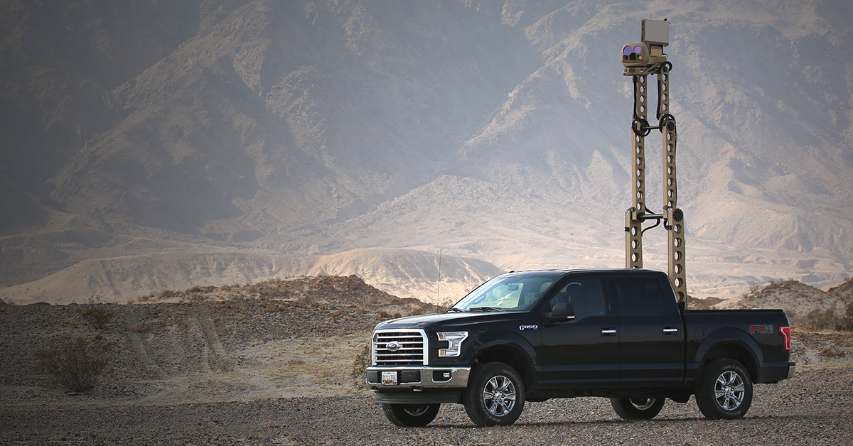
Target Acquisition (TA) and Battle Damage Assessment (BDA) frequently merge observation, range finding, and target designation equipment. These systems are mounted on a goniometer to ensure the alignment and precision necessary for the weapon in use. Targeting systems might be integral to the weapon systems – for example, combat aircraft, attack helicopters, or tanks – or utilised by a specialised reconnaissance or fire support vehicle. Vehicular systems, less restricted by space, weight, and power, achieve longer ranges and higher resolution. However, since these assets must maintain a direct line of sight with their targets, they are inherently exposed and vulnerable to enemy fire.
To enhance the survivability and resilience of dedicated TA assets, sensors are affixed to telescopic masts. This setup enables the vehicle to operate from a defilade position or under a tree canopy. Dismounted teams also manage portable equipment. Both methods rely heavily on camouflage systems to conceal their position and favour maintaining a static position as long as they remain undetected. With the advent of smaller, lighter payloads, these missions are increasingly assigned to unmanned systems – autonomous ground vehicles, fixed-wing, and multirotor drones. The latter also excel in BDA as they can maintain continuous coverage of the target throughout the engagement.
Credit: Teledyne FLIR
Besides improving crew security and safety, these platforms have introduced a new capability: the ability to conduct tactical observation and target acquisition Beyond Line-of-Sight (BLOS). Matching this function with precision-guided weaponry has introduced a new and transformative capability to the modern land battle.
Surveillance Systems
Observation systems are critical in surveillance missions, encompassing border and coastal defence, force protection, and public or infrastructure security. These missions necessitate ongoing surveillance of specific areas, a task often challenging for human operators due to the high concentration and alertness required over extended shifts. The employed equipment blends a myriad of sensors designed for day, night, and adverse weather operations. The fusion of visual intelligence and radar is highly beneficial due to the radar’s ability to detect movement and cue the observation system to scrutinise the detected activity.
This integration can also harness unattended sensors placed throughout the area under surveillance. Modern devices capable of wide-area surveillance also provide data for video motion detection and automatic target recognition. This enables systems to undertake much of the routine surveillance tasks, allowing operators to concentrate on analysing suspected targets and high-alert situations.
While most surveillance networks depend on a static sensor network, even the most robust system has some vulnerabilities that seasoned and determined adversaries could exploit. Incorporating mobile segments into such a network enhances the overall system’s efficiency. Mobile observation posts may use relocatable unattended sensors, mounted patrols, or drones. These can be deployed pre-emptively based on intelligence information or ad-hoc to strengthen specific lines of access where adversary activity is anticipated.
Summary
Intelligence gathering, surveillance, and reconnaissance have always been pivotal elements of military strategy. Despite the profound transformation of ISR methods through technological advancements, their founding principles remain relevant. This article explored various facets of ISR, from intelligence gathering and target acquisition to border surveillance and security.
Visual intelligence plays a critical role in amassing and processing visual information. With advances in video processing, AI/machine learning, and automatic target recognition, users are now better equipped to exploit this information. Consequently, sensor operators are transitioning into analytical roles, and information processes are being automated into real-time information systems. As technology continues to evolve, the future of ISR holds immense potential to elevate situational awareness and decision-making capabilities within military operations.
Tamir Eshel


